
BARSC member, Harris is offering a free, fully-functioning six month trial of their Unmanned Aerial Vehicle (UAV) and aerial photography software; ENVI OneButton.
 Explosive growth in the Unmanned Aircraft Systems (UAS) market, coupled with the evolution of inexpensive miniaturized sensors, has made aerial imagery easier and cheaper to acquire than ever before. Information from that imagery is commonly used to develop new applications, update GIS maps, and to make better business decisions. All of this is driving the need for software tools that can speed up the time between image capture and decision making.
ENVI® OneButton™ software is by far the industries’ easiest-to-use image processing software. By utilizing the most advanced photogrammetric and
computer vision algorithms, ENVI OneButton lets you easily and automatically create fully georeferenced products in 2D and 3D while combining highly
optimized performance to produce exceptionally fast and accurate results.
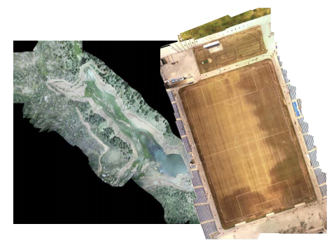
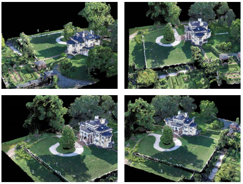
Outputs that can be produced from ENVI OneButton include orthomosaics, Digital Elevation Models (DEMs), true color 3D point clouds, orthorectified multispectral mosaics, and controlled oblique imagery, all of which can be further analyzed in ENVI software.
 Orthomosaics from ENVI OneButton are produced from overlapping aerial images that are stitched together and geometrically corrected (“orthorectified”) to give them a uniform scale. This process removes perspective distortion from the aerial images, making a resulting “mosaic” map that can be accurately measured and analyzed.
Processed, georeferenced and orthorectified imagery products are output in a form that can be automatically ingested into your GIS and analytics packages such as ENVI, supporting complex analytics for applications including precision agriculture, pipeline inspection, real estate visualization, construction and engineering projects, and many others.
Regardless of your experience, ENVI OneButton lets you immediately increase ROI, begin building exciting new applications. This dramatically lowers the cost of ongoing data collection and processing for existing applications.
To enable you to learn more, Harris is running a series of webinars during which they will:
- Demonstrate ENVI OneButton technology and show how easy it is to generate geolocated orthomosaics from UAV and aerial imagery
- Use ENVI + IDL to pre-process UAV imagery with the UAV Toolkit so that it is in an ingestion-ready state for ENVI OneButton
If you want to go from UAV and aerial data to actionable information in the push of a button,
sign up now for the webinar in your region.