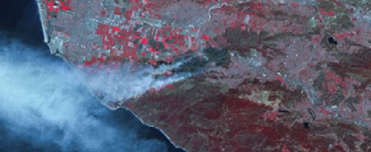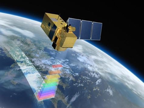
Image Courtesy of SSTL / DMCii
• Big Sur wildfire destroys 15 homes and 500 acres of national forest – 17 December 2013
• Bushfires rage across New South Wales for seventh day – 23 October 2013
• California wildfire threatens San Francisco water supply – 27 August 2013
• Arizona wildfire escalated rapidly before 19 fire fighters were killed – 16 July 2013
Fires in forests and grasslands are a natural phenomenon, and ecosystems such as tropical savannahs and the boreal forests of North America have evolved with wildfires an important component of their makeup. However, devastatingly large or severe wildfires, or fires considered to be burning too close to human habitation, can be a regular event in many parts of the world, and the majority of them are started by human activity. At the same time, fire is a regular tool used in the clearing and deforestation of the rainforests, and many agricultural areas use burning as a way to clear crop residues left after harvesting, in preparation for new planting.
As a result, global biomass burning is the second largest source of many of the trace gases in the atmosphere, and the largest source of fine carbon particles. Monitoring of these vegetation fires is critical for understanding the carbon cycle and atmospheric composition, and for forecasting instances of air pollution caused by fires burning hundreds or perhaps thousands of km upwind. It can also provide valuable data relevant to both weather and climate forecasts.
All these forecasts are based on sophisticated computer models, and a key parameter in the models is the emission rate of smoke from the fires. But how can smoke emission be measured on a global scale? The detection and measurement of fires from space has been demonstrated using a variety of infrared instruments mounted on satellites. These measurements are achieved using a combination of spectral bands in the visible, mid-infrared (3-5 μm) and long-wave infrared (8-14 μm) parts of the electromagnetic spectrum, in order to distinguish the signature of fires from those of clouds and sun glint. These can be confused if only measured using the visible spectrum.
To date, the technology to make these measurements has required use of expensive cooled detectors. So a project was recently undertaken by a team from King’s College London and Surrey Satellite Technology Ltd (SSTL) to explore the performance of new broadband infrared uncooled detectors and new processing techniques. The objective was to assess the feasibility of achieving an adequate performance at much lower cost.
Three characteristics of fires directly derivable from space borne remote sensing data are the rate of radiant energy emission from the fire, the fires’ effective temperature, and its sub-pixel “active fire” area. This is the instantaneous area undergoing combustion at the time the imagery is acquired, and typically this area is very much smaller than the pixel size.
Despite being a simplification of the actual fire situation, such data is considered highly useful in a variety of wildfire measurement and/or modelling scenarios. For example, these metrics feed into estimates of pollutant emission, e.g. CO2, CO, CH4, particulates. The value of these estimates is obvious, especially in light of national and international legislation on pollution control. Unfortunately, the datasets from different EO sources can have large biases, uncertainties and differences due to differences in sensor design and operation, leading to great variability in emissions estimates.
 Several satellite instruments (MODIS, the GOES Imager and Meteosat SEVIRI) have been able to estimate the fire radiative power, effective temperature and fire size of a wide range of global fires. However, these instruments have a coarse spatial resolution (1 x 1 km or larger); probably the best currently available datasets comes from the BIRD small satellite mission, whose footprint on the ground was 0.37 km square.
Direct comparison of imagery between the coarser and finer spatial resolution data shows that the amount of fire can be seriously underestimated in the former, especially with respect to areas characterised by many lower temperature or smaller hot spots. Furthermore, the smaller the pixel size the greater the proportion of flaming and smouldering combustion is captured in each pixel, and the less cooling ground is included, improving the quality of the measurement.
The BIRD satellite was designed for fire monitoring, using cooled CdHgTe detectors. But these require more space, power and mass than uncooled technology, limiting their use on smaller, lower-cost satellites. The Stirling engines used to cool the detectors may also have a limited lifetime.
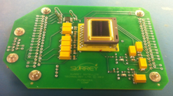
The project team investigated the performance of an uncooled micro-bolometer technology combined with modified time-delay-integration readout techniques. They developed a prototype system that does not have any identified lifetime limitations, and has a spatial resolution comparable to or better than the BIRD mission. In achieving this, the project team generated several important findings, including:
1. A review of fire behaviour which identified 22 key requirements for a dedicated space based fire detection instrument, the three most important being: observational wavebands; absolute radiometric accuracy per channel; and saturation temperatures
2. An experimental study of a commercial micro-bolometer detector technology, confirming its suitability for the application, especially with respect to its spectral response (3 – 16 µm), responsivity and its sensitivity, which are all key metrics for fire detection.
3. A radiometric analysis for a dedicated fire measurement and monitoring space based instrument, which provided the instrument optimum measurement geometry (aperture diameter), system dynamics principle, and noise performance estimates.
The project has provided a baseline list of mission and system requirements for a single dedicated fire measurement and monitoring system, enabling the development of the next generation of satellite based instruments. It has shown that commercially available 2-D micro-bolometer array detectors are capable of reaching the required noise performance in MWIR and thermal infra-red (TIR) wavebands given the correct readout schemes. And it has shown that the range of minimum aperture diameters as a function of orbit altitude for the MWIR and TIR wavebands are between 3 cm and 8 cm.
The Centre for Earth Observation Instrumentation (CEOI) is funding a wide range of innovative new instruments that measure our weather, our atmosphere, the icecaps, and many other aspects of the natural environment.
The information from these instruments is constantly improving our understanding of our planet and how human activities are affecting it.
Further information about this technology and others funded by the CEOI can be found at www.ceoi.ac.uk. You can also contact the CEOI Director, Professor Mick Johnson: Tel: +44 (0)1438 774421 or email: mick.johnson@astrium.eads.net

