
Explosive California wildfires have ravaged over 20,000 acres of land in Riverside County causing misery for residents. The satellite image below, captured by our DMCii 22-metre multispectral satellite UK-DMC2 on Tuesday 13th August, shows burn scars caused by the blaze.
Palm Springs can be clearly seen to the right of the charred land, the artificial red showing areas of growing vegetation detected by invisible near infra-red spectra.
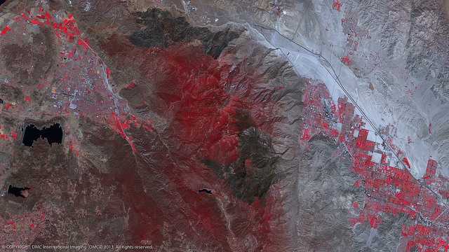
Wildfire burn scars surrounding Palm Springs. Image acquired by UK-DMC2 © DMCii, 2013. All rights reserved
This satellite image captures the damage caused by the recent wildfires, which began on 7th August.
California residents experience wildfire season every year, but scientists are in common agreement that climate change is making it increasingly likely for extreme events, such as wildfires, to occur.
Satellite images also show the close proximity of wild land areas to growing urban developments, increasing the risk to inhabitants, and leading to an increase in wildfire damage that already accounted for $13.7 billion in economic losses from 2002 to 2011. Experts believe that this year’s fire season could go down as the worst in US history.
California officials were able to safety evacuate 1,500 people from their homes. Over 800 fire fighters, 40 fire engines and nine helicopters have succeeded in containing the blaze. The wind-driven fire caused 13 injuries and destroyed 48 structures.
Satellite imagery provides a snapshot of stricken areas that can be used to produce maps and plan relief efforts – as shown in this comparison of California land before, during and after the wildfires in May 2013. DMCii regularly assists in global disaster response by supplying satellite imagery to governments and relief agencies and plays an active role in the International Charter: Space and Major Disasters.
Visit www.dmcii.com for more information.