
An international team, led by the University of Nottingham in the UK and including BARSC member Specto Natura, is developing the SAtellite SArgassum Monitoring System (SASAMS).
This is planned to be a near real-time service for monitoring pelagic sargassum seaweed beaching, initially aimed at Mexico’s Caribbean Coast.
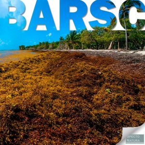
For the last decade, the Caribbean has been seriously impacted by the excessive accumulation of sargassum (a brown macroalgae), causing large-scale economic, environmental and ecological problems.
Predicting the arrival and managing the impact of sargassum, which turns clear sea water brown and smells of rotten eggs, has been cited as a priority for the Mexican government.
However, there is limited understanding of sargassum beaching and how it is affected by changing sea conditions as a result of global warming. The development of this satellite monitoring system will significantly advance research and enable practical solutions for the management of sargassum.
The dynamic nature of ocean currents and coastal zones renders conventional ground-based monitoring of sargassum, ineffective.
This situation also hinders any activity to deal with the negative environmental and economic effects of sargassum beaching as it builds up and eventually rots.
Earth Observation (EO) and cloud-based image processing now offer the potential to monitor any location around the globe on a regular basis and at a scale that allows localised responses to changing conditions.
The SASAMS project brings together a diverse skill set to address the problem.
The University of Nottingham has considerable expertise in EO, environmental science and environmental management.
However, the project gains greatly from involvement of major Mexican partners with substantial expertise in sargassum research and remote sensing: the National Commission for the Knowledge and Use of Biodiversity (CONABIO), the Centre for Research in Sciences of Geospatial Information, A.C. (CentroGEO) and the National Autonomous University of Mexico (UNAM) Centre for Atmospheric Sciences.
The team also includes UK-based Specto Natura, experts in environmental monitoring from space, and IPE Triple Line, experts in project management.
The team will make use of contemporary EO data sets from Planet Inc. which operates the largest single constellation of Earth imaging satellites offering 3m spatial resolution of the globe daily with the capability for more detailed images of selected sites.
The project will ultimately develop tools to track, quantify and understand sargassum beaching remotely.
The service will be designed to detect and monitor the seaweed at scales that are relevant to local users, regional managers, and state and national governments.
This will enable Mexican federal and state agencies to allocate resources to the affected areas quickly and efficiently, thereby minimising economic, social and environmental impacts and enhancing the resilience of local communities and the tourist industry.
In this discovery phase of the project the partners will build on existing stakeholder communities and engage with potential users to determine their requirements for a monitoring service. A prototype will be developed and demonstrated to the stakeholders and users to gain further feedback on their requirements of an operational SASAMS service.
The team will adopt cutting edge EO, cloud processing and service delivery technology to provide near-real-time, location-specific sargassum information in an intuitive and user-friendly fashion.